A half-century-old control structure is the only thing that stands between the mighty Mississippi and its preferred path to the sea. If that structure fails, the consequences could stagger the nation.
The Mississippi River is a foundational piece of America’s infrastructure, serving agriculture, commerce, and industry for most of the U.S. heartland. Nowhere is the river more important than in southern Louisiana, where it performs critical functions, not just for shipping, but for the oil and chemical industries. But the river’s not a piece of technology, like a highway or bridge; it’s a living creature—powerful, wild, and fickle. And if your livelihood depends on the river, you need to stay aware of an ever-present question: What is that river going to do? In the worst case, the river could change its course drastically — a disaster that scientists recently estimated is quite possible, as the Baton Rouge Advocate reported in February (see: “Could Mississippi River change course? New research raises question, but Corps says plan working,” by Steve Hardy).
The Mississippi River has not always flowed on its current course. On the contrary, it has a habit of shifting its path. Like every huge river on the globe, it carries silt with it to the ocean, and deposits the silt on its gigantic delta. As the delta grows, the river’s path to the ocean grows longer and more shallow. In the natural way of things, at some point, the river will choose a shorter and steeper path instead.
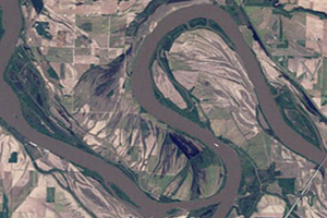
Historically, the Mississippi has shifted course every thousand years or so, according to experts; and left to its own devices, it would shift course again — right now. The only thing preventing the river from leaving its bed and following a more westerly course along the Atchafalaya River — bypassing Baton Rouge and New Orleans almost completely — is a complex of control dams built in the 1960s, and improved in the 1990s, known as the Old River Control Structure.
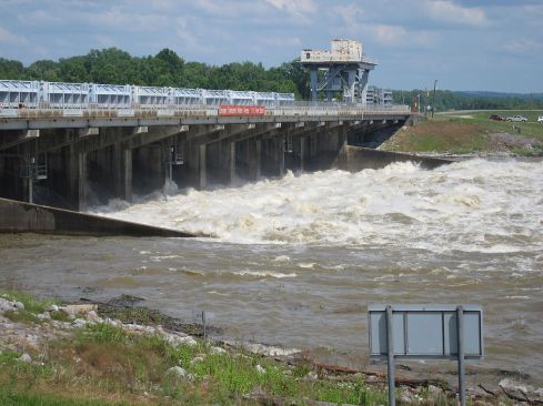
Mississippi River water discharge into the Atchafalaya, Old River Control Structure, Louisiana. (photo: Tobin)
In a classic New Yorker story in 1987, John McPhee likened the continual maintenance and monitoring of the structure to strategic battle (see: “Atchafalaya,” by John McPhee): “The consequences of the Atchafalaya’s conquest of the Mississippi would include but not be limited to the demise of Baton Rouge and the virtual destruction of New Orleans … For nature to take its course was simply unthinkable. The Sixth World War would do less damage to southern Louisiana. Nature, in this place, had become an enemy of the state.”
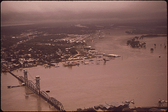
Near Morgan City, La., in 1973, the Mississippi river reached its highest level in more than 150 years. Unprecedented flooding occurred throughout the river basin. (photo: National Archives)
McPhee’s long-form essay describes how a 1973 flood very nearly destroyed the control structure, eating away at its foundations and prompting a costly reconstruction and repair project. More recently, a major flood in 2011 threatened to overwhelm the control structure again and irrevocably shift the Mississippi’s course.
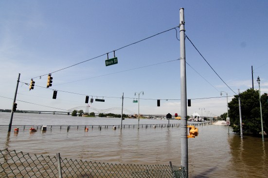
Flooding at Riverside Blvd. and Beale St. in downtown Memphis, Tenn.; part of the 2011 Mississippi River floods (photo: Thegreenj)
Now, according to LSU hydrology professor Yi-Jun Xu, there’s a new long-term change in the river that could make a future flood even more risky. The New Orleans Times-Picayune has this report on the recent research (see: “Rising river bottom could switch Mississippi to Atchafalaya riverbed in next mega flood,” by Mark Schleifstein). “The next Mississippi River mega flood in Louisiana could see its water overwhelm the Old River Control Structure above Baton Rouge and cause the river to switch its flow to the Atchafalaya River basin, according to a research scientist with the Louisiana State University School of Renewable Natural Resources,” the paper reported.
“What’s leading to the potential river bed switch is the filling of the Mississippi’s river bed with sediment along an area just below the Old River Control Structure,” explained the Times-Picayune. “That section of the river bed has risen more than 30 feet in the past 20 years, leaving less room for the water carried by the flow to the Gulf. During a major flood, it will act like a stopper, causing water to back up and rise higher than the present Old River Control structures.”
In a statement, the U.S. Army Corps of Engineers, which has the job of taming the Mississippi, said that it is studying the problem. Complicating the issue is the problem of climate change: while previous studies of flood risk have been based on historic data, climate researchers say the occurrence of very large and heavy rainfall events is increasing as the world warms. Worrying signs of this possibility include a succession of extreme rainfall-caused floods in recent years, such as 2010’s so-called “1000-year flood” in Tennessee, 2016’s Louisiana flooding, and last year’s catastrophic Hurricane Harvey.
Whether the risk is caused by random weather variation or long-term climate trends, there’s little doubt that relying on the control structure to hold is a high-stakes gamble. As Fred Bayley, then a chief engineer with the Corps of Engineers, told John McPhee back in 1987: “Anything can fail … I never approach anything we do with the idea that it can’t fail. That is sticking your head in the sand.”